


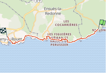
Niolon carry le rouet par sentier des douaniers

cyrghe
User

Length
14.8 km

Max alt
73 m

Uphill gradient
390 m
Km-Effort
20 km

Min alt
0 m

Downhill gradient
420 m
Boucle
No
Creation date :
2022-10-02 07:47:12.0
Updated on :
2022-10-02 14:02:50.589
5h05
Difficulty : Unknown

FREE GPS app for hiking
 SityTrail
IGN / Geographical institutes
SityTrail Plus
The world is yours!
About
Trail Walking of 14.8 km to be discovered at Provence-Alpes-Côte d'Azur, Bouches-du-Rhône, Le Rove. This trail is proposed by cyrghe.
Description
Belle ballade au fil de petits ports et calanques … 👍👍👍
Positioning
Country:
France
Region :
Provence-Alpes-Côte d'Azur
Department/Province :
Bouches-du-Rhône
Municipality :
Le Rove
Location:
Unknown
Start:(Dec)
Start:(UTM)
682936 ; 4801087 (31T) N.
Comments